
![]()


For Survey Organizers
Survey of Washed-up Debris Organizer's Manual (for those in charge)
I. Preparation in advance
1. Requirements of the survey beach
(1) The target beach for the survey (hereafter referred to as "survey beach") should be a sandy beach where the participants can perform activities safely. For accurate data comparisons, beaches that fall under any of the following conditions should be avoided.
1) Beaches located within 1 km either side of the mouth of a large river such as a class A or class B river.
2) Beaches in front of which wave breakers or other obstacles are placed.
(2) The timing of the survey should be once during autumn (September–November). Survey should be carried out about one month after the end of the peak season for the beach (for swimming, etc.). In cases such as where participating organizations are different, more than one survey is allowed at one beach. In such cases, however, the survey periods must be separated and the survey blocks must be set on different locations in order to avoid overlapping.
2. Conducting basic surveys of the beach
(1) Research the intended use of the beach, how surrounding land is being used, whether there are trash cans and vending machines or not, its distance from rivers, its cleanliness, and the annual number of people it is used by, and record the information on the Survey Beach Data Sheet (refer to Appendix 1).
(2) Inspect the survey beach in advance and decide upon where to set up the survey blocks for the survey of washed-up debris, the number of survey blocks, and other arrangements. (Also confirm the location of toilets and the parking lot to be used by participants.)
(3) Prepare a map of the surrounding area of the survey beach (approx. scale: 1 to 1,500-3,000), and mark on it the aspects of the area surrounding the survey location (including the survey blocks).
3. Preparing necessary equipment for the survey
(1) To prepare necessary equipment for the survey refer to Appendix 2.
Mark in advance the survey beach code and survey block/point code (refer to Appendix 3) on the survey summary sheet 1 & 2.
(2) The time taken for the survey should be within 2-3 hours, and a sufficient number of participants should be acquired to be able to conduct the survey efficiently and effectively taking into consideration the number of survey blocks, amount of washed-up debris, etc.
(3) Inform the participants in advance of the meeting place, meeting time and how to get to the survey beach, etc.
(4) Create the survey schedule for the day of the survey (refer to Appendix 4) and give it to everyone involved.
(5) Create a contact network to inform of implementation or postponement of the survey.
(6) Establish a place to gather the washed-up debris, and coordinate collection and disposal of it with the relevant municipality.
(7) Create the questionnaire to be given to participants after the survey (refer to Appendix 7). (Optional)
4. Setting up the survey blocks and points
(1) Setting up the survey blocks for the survey of washed-up debris
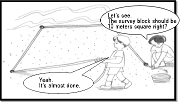
1) Select an area where an average state of coastal washed-up debris can be comprehended, and set approximately three continuous ten-by-ten meter blocks (hereafter referred to as "survey blocks") in an inland direction from the water's edge (approximately 30 meters from the water's edge), where the water's edge is a relatively dry zone with infrequent breaking of waves.
2) A survey area in principle should be one row of survey blocks; however, if it is not possible to allow three blocks in one row due to insufficient depth of the beach, set multiple rows leaving a ten-meter space between them. (Refer to Appendix 5.)
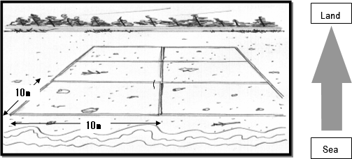
3) Where it is not possible to allow the farthest survey block from the water's edge to have an area of 100 m2, measure the area of the sandy part of that block and write it down on the Survey Beach Data Sheet.
4) Plant a stake on each corner of the survey blocks and stretch nylon cord or something similar between each pair of stakes in order to define the survey area. (It is also recommended to prepare the square blocks in advance by tying the nylon cord to the stakes in order to set up the survey area quickly at the actual site.)
(2) Operations after setting up the survey blocks and points
1) Measure the distances from the water's edge to the clusters of washed-up debris within the survey blocks for each row, and write them down on the Survey Beach Data Sheet.
2) Take photos of the survey beach (including surrounding areas) and the setting conditions of the survey blocks/points, as well as other noticeable things, using a digital camera.